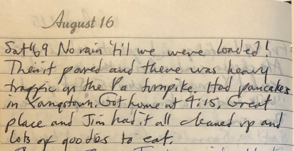

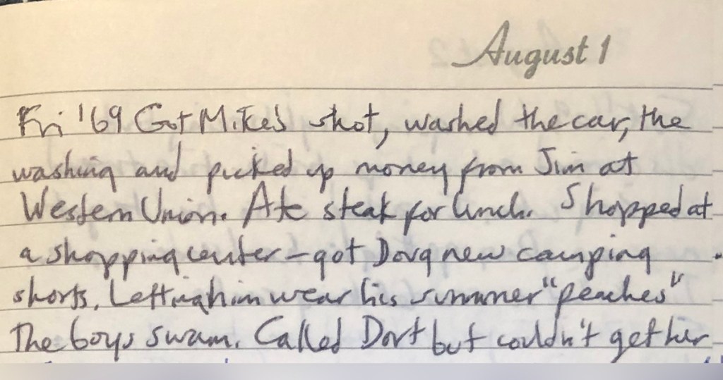
Got Mike’s shot, washed the car, the washing and picked up money from Jim at Western Union. Ate steak for lunch. Shopped at a shopping center—got Doug new camping shorts. Letting him wear his summer “peaches.” The boys swam. Called Dort but couldn’t get her.
Marge Binder, August 1, 1969
There’s a lot to unpack here, no pun attended.
Dort
My Aunt “Dort” Dorothy was the oldest of my Dad’s siblings. She was a judge in the Denver area and a revered character in our Family. She was a protector and champion of Dad since childhood, and Tim greatly respected. She passed away just last year. Sadly, I never met her.
“Peaches”
Not a clue what this means. Mom claims not to recall. It’s probably best we leave it at that.
A Different Time
How much the world changed since 1969, some of which we’ve explored on this scroll. One detail of today’s diary entry references calling [Aunt] Dort but “couldn’t get her.” That’s what happened back then, before even simple technologies like answering machines. You call someone, they don’t answer, you move on. In this case, you drive on home another 2,500 miles and don’t see them for decades.
And Western Union is a blast from the past. I’d practically forgotten about them.
Money Handling in 1969
This is the first time Maw cites a means of finances — a stop at Western Union to pick up a money wire from Dad. Western Union (or WU, as it calls itself in its umpteenth rebranding since then) was the world’s largest provider of telegraphic services — telegrams. In doing some cursory research for this blog, I was surprised they’re still thriving in niche but modern markets.
As for how Mom managed money on this long trip, she offered some insights recently. Credit cards were not so in vogue yet. Debit cards were still 25 years away. I was surprised that Maw didn’t use travelers’ checks on this trip. She traveled with a checkbook but few banks would cash them; the big chains didn’t cover the whole country yet, or were few and far between, or were open only during “banking hours.”
Maw tells me she kept a few hundred dollars in cash to cover things, from gas and food to lodging and doctors. I suppose that’s a pretty straightforward way of doing things, but it certainly doesn’t feel secure by today’s standards — as ironic as that sounds.
Also, note in Mom’s diary what happened right after fetching the cash: “Ate steak for lunch.” That’s just how she rolls!
ATMs and Beyond
Can you imagine living without ATMs? This Gen-Xer cannot. 25% of Boomers, though, don’t use them at all.
A Chemical Bank on Long Island brought America’s first ATM on-line in 1969, advertising the occasion thusly: “On September 2, our bank will open at 9:00 and never close again.” (Get ready for the 50th anniversary of that next month!) The machines were first called Docutellers after the company that innovated the technology, Docutel. Today, there are more than half a million ATMs in the US, one for about every 650 people.
These days, of course, lots of people can live without ATMs, thanks to mobile apps, blockchain and even cryptocurrencies. I’m sure their recollections of these innovations 50 years from now will sound as stale as my defense of the ATM.
Party on, people of the future! And Peaches!